
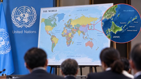
Japan has raised concerns over the portrayal of the Kuril Islands on a newly adopted world map that utilizes the Equal Earth projection, sparking a debate over territorial representation. This map projection aims to more accurately depict the relative sizes of continents compared to the widely used Mercator projection. Consequently, it presents Africa as much larger, while reducing the apparent size of Europe and North America.
The controversy centers on Japan’s objection to the depiction of the Kuril Islands, which it calls the Northern Territories. On the map, these islands are colored the same as Russia, leading Japan to argue that this could cause confusion about the ownership of the territory, which has been a point of contention between the two nations for decades. The islands form a chain between Japan’s northern region and Russia’s Kamchatka Peninsula, making them a significant geopolitical and historical issue.
This dispute underscores the powerful role map design can play in influencing perceptions of borders, territories, and geographical ownership. Mapping systems like the Equal Earth projection can alter the visual representation of countries and continents, even though their actual sizes and locations remain unchanged. This particular projection was developed to offer a more balanced depiction of global land areas, avoiding the distortions near the poles caused by the Mercator projection.
The discussion around the new map highlights the deep cultural and political meanings that can be embedded in maps, beyond their utility as travel guides. Colors, borders, and labels on maps can impact international relations, especially in areas where territorial boundaries are still disputed. For those interested in geography and travel, the Equal Earth projection provides a fresh perspective on the world, illustrating how the appearance of well-known destinations can vary depending on the mapping system employed.